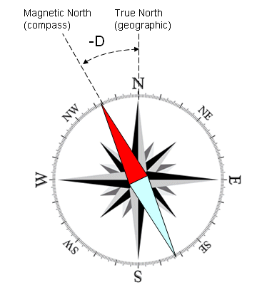
When we’re kids, we know that down is south and up is north. Where a compass points is where Santa lives, and it’s at the top of the map. Life is simple. But when we become men (and women), start doing land nav, and put away childish things, it gets a little more complicated. Because we learn that there’s not one north, but three. One is where your compass points, the other is where the lines on the map come together, and neither of them are true north. This presents a quandary.
In order to remedy this, there’s a thing called magnetic declination. And although it’s vitally necessary for accurate land navigation, calculating declination is probably the thing that is the most confusing to new students of the art. To be completely honest, it took me years to wrap my head around it, even though it’s a simple concept.
On its face, all declination is, is the angle of difference that exists between grid north (what you see on your map) and magnetic north (where your compass points.) Why does this matter? Well, if you shoot your bearing based entirely on the heading you pulled from plotting your points without calculating declination, your compass will be off by that many degrees. If you’re in an area close to the agonic line (where declination is zero) and you’re only going on short hops of a few dozen meters or so, you’ll be fine. But if the legs of your course are hundreds of meters (or a few kilometers) long, or you’re in an area with high degrees of declination (like Maine, or the Rockies), you’re in trouble. By the time you reach your destination, you’ll be hundreds of meters off course, and quite possibly lost. I know from my military buddies that failing to calculate declination is a common mistake among rookie field officers – one of the reasons behind the phrase, “You can’t spell ‘lost’ without ‘LT’.”
The confusion with declination, at least for me, comes in when it comes to adding and subtracting. Here’s a helpful way to think about it. Remember the agonic line? That’s where grid north and magnetic north line up. Like the rest of the earth’s magnetic field, it shifts over time. Fun fact – in the early 1970s, it used to run right down Main Street of Ball Ground, Georgia. But nearly all of us are either west or east of it. The current declination where we are in north Georgia is dead on 5 degrees west. Meaning, that there’s 5 degrees of westward difference between the agonic line and grid north. In the Rockies, it’s about 16 degrees east. Meaning, that if you were to take a protractor and measure the difference between grid north and the agonic line, it would be 16 degrees east. How do you know what the declination is in your area? Any map should have it in the bottom right corner, and it should look something like this:
How does all this add up? Think about it. We’ll use Georgia as the example again. If there’s 5 degrees of westward declination between the grid heading you’ve plotted out and where your compass is pointing, then you need to change your heading 5 degrees to compensate and get you where you actually want to go.
If you’re going from a compass reading to a heading on paper, you add the degrees of declination to it. If you’re going from paper to your compass, you subtract. A good way to remember it is an old Army trick: Generals are always above Majors. If you’re going from Major to General, (magnetic to grid) you add. If you’re going from General to Major (grid to magnetic) you subtract. But isn’t a westward declination like we have here “less” than grid? Yes. Westward declination is always negative, eastward is always positive. Add or subtract it as a negative number. For instance, in Georgia it’d be whatever your heading is, +(-5) if you’re going from compass to map (M to G), and –(-5) if you’re going from map to compass (G to M). This handy diagram may help you:
Of course, there is an easy way around all this: Buy a compass that’s adjustable for declination. Most higher-end compasses can do this. On a Suunto, it’s an adjustment screw on the underside of the bezel. Bruntons have a press-and-twist mechanism to adjust it. Just make sure that if you travel outside of the area you normally train in, you change your declination settings to match. However, even if you have gear that compensates for it, knowing how to do declination is a critically important skill in land navigation. If there comes a point that you have to use your backup compass that isn’t as nice, or are borrowing someone else’s, then you’ll have to calculate it the old-fashioned way.
I hope that clears the subject of declination up somewhat. For me, the only thing that helped was doing lots and lots and lots of land nav. If you’d like to practice this skill in the field under the watchful eyes of Jonathan and myself to help you make sure you get it right, join us for Land Navigation Essentials this coming Saturday, March 30th from 9am-7pm! We’d love to help you work through it! Learn more and register at www.sarcraft.com/land-navigation-essentials!
- Alex


